The Celestial Sphere
The Celestial Sphere
We all know we live on a spinning globe but in order to help visualise what we observe, astronomers introduce the concept of the celestial sphere.
Imagine the sky as a great hollow sphere of infinite radius surrounding the Earth, with the stars attached to the inner surface of this sphere. This imaginary sphere (the celestial sphere) is a very convenient way to visualise the apparent motion of sky.
While we all know the Earth rotates, it is much simpler, to assume we are at rest and that the celestial sphere rotates around us. We then say that the rotation of the celestial sphere causes the stars to rise in the East and set in the West, i.e. the celestial sphere rotates westwards (objects move to the West). Thus it seems that the celestial sphere rotates about the observer once every ~24 hours.
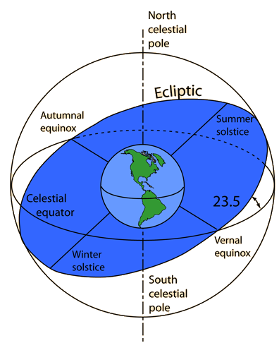
The North and South poles of the celestial sphere (NCP and SCP) correspond to outward projections of the Earth’s poles. The celestial equator is the outward projection of the Earth’s equator to the celestial sphere.
To identify positions on the celestial sphere, we use an equatorial co-ordinate system that mimics the Earth’s longitude (e.g. the angle around the equator: Right Ascension (RA)) and latitude (e.g. up/down angle from the equator: Declination (Dec)). This coordinate system is fixed to the celestial sphere, i.e. “fixed” to the stars.
Every object on the celestial sphere has a unique RA-Dec position. For example, the bright star Arcturus’ position is RA = 213.894° and Dec = +19.191°. One subtlety of the RA-Dec co-ordinate system is that RA is measured in units of time (hours, minutes, seconds with 24 hours being equal to 360°), while Dec is measured in the usual units of angular measurement (degrees(°), minutes(‘), seconds(“)). Hence Arcturus’ position is usually listed as RA = 14h 15m 34.5s and Dec = +19° 11′ 13”. Note that minutes and seconds of RA are different units to the (arc)minutes and (arc)seconds of Dec.
On the surface of the Earth the longitude co-ordinate starting point is the Prime Meridian at Royal Greenwich Observatory which is taken as 00° 00′ 00″. Durham’s longitude is 1° 34′ 56.3″ west. The starting point of RA is defined by the vernal (March) equinox, i.e. where the Sun crosses the celestial equator moving from south to north (see the ecliptic page). Dec = 0° is defined by the celestial equator, i.e. the projection of Earth’s equator onto the celestial sphere. Objects above the celestial equator have positive declinations, e.g. Arcturus. Dec = +90° defines the north celestial pole (NCP) and is directly above the Earth’s north pole. Dec = −90° defines the south celestial pole (SCP) and is directly above the Earth’s south pole.